Utah once had many ancient lakes. We can see were the lakes were by studying the landscape and learning about the state’s geographic history.
Have you ever been to the Salt Flats, a level plain of white salt extending for miles west of the Great Salt Lake? Can you believe that thousands of years ago a vast lake stood where it is bone dry today?
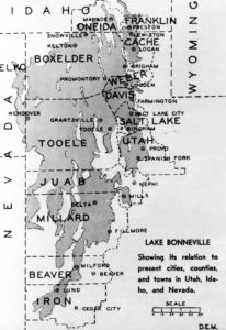
Lake Bonneville was 325 miles long, 135 miles wide, with a depth of up to 1,000 feet. The enormous lake once lay on the eastern section of the Great Basin, which is shaped like a bowl. There’s no way for water to escape the Great Basin other than through evaporation. The terraces, or benches, along the foothills of the Wasatch Mountains and other ranges in the region are evidence that at one time water rose higher than we can easily imagine. Terraces formed as water lapped on a particular shoreline for long periods (we’re talking hundreds, even thousands of years). These formed in succession as the water levels dropped and stabilized for a time. Lake levels rose to an all-time high 18,000 years ago—known as the Bonneville level.
About 16,800 years ago, water levels had risen to the height of the lowest outlet for Lake Bonneville at Red Rock Pass in what is now Idaho. As the waters flowed through the pass into the Snake River Basin, it cut into the channel, causing a flood that dropped the outlet levels by 375 ft. From 16,200 years ago to the nineteenth century, lake levels slowly declined until the massive lake itself disappeared, leaving behind wet remnants, including the Great Salt Lake.
Keep Exploring!
Return to the Places page here.
Return to the I Love Utah History home page here.