Beaver County was designated in 1856. Plants, animals, and people occupied the land long before that date.
What is the Land Like?
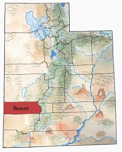
The massive Tushar Range marks the eastern boundary of Beaver County. Delano Peak (12,173 feet) and Mount Belknap (12,139 feet) are among the highest mountains in the state. Trees, wildlife, and creeks flourish in these mountains, providing resources for residents of the city of Beaver and other towns.
Several other mountain ranges, typical of the Basin and Range province, rise over the country that stretches to the border of Nevada. Between them lie five north-south running valleys. Beaver Valley is most fertile, watered by streams flowing from the Tushars. Milford Valley is the largest flat area and includes the northern part of the Escalante Desert.

First Peoples
Archaic and Sevier Fremont cultural sites have been found here, and in historic times the area was part of the Southern Paiutes’ territory. Obsidian from the Mineral Mountains was used by the prehistoric inhabitants of much of central Utah to make stone tools. Paiute people continue to live in the region today.
History
In 1776 the Dominguez-Escalante expedition crossed the county near present-day Milford. Jedediah S. Smith (1826-27) and John C. Fremont (1844) had also traveled in the Beaver area. Parley P. Pratt and his exploring expedition passed through in January 1850; Pratt wrote “This is an excellent place for an extensive Settlement.” But it took another six years for settlers to move in. The Territorial legislature created Beaver County in January 1856, and the first group of settlers moved to the new county in February.
Fort Cameron

In 1873 the U.S. Army built Fort Cameron in Beaver City. The troops came to protect against Indian hostilities, but also to support the 2nd District Court in prosecuting John D. Lee and others accused of participating in the Mountain Meadow Massacre. Lee stood trial twice in Beaver, and he was briefly imprisoned at the fort.
After the army abandoned the fort in 1883, the town established the Murdock Academy there. From 1898 to 1922 the Academy was a part of the LDS school system and a branch of Brigham Young Academy, the forerunner of BYU.
Economy
Although the early settlers planted crops and grazed livestock, the county prospered in the 19th century because of a unique blend of mining, transportation, and trade in addition to farming.
In Beaver City, the Beaver Woolen Mills turned out woolen goods from the 1870s to the turn of the century. The mill sold many of its products, especially blankets, to the miners in Frisco.
The Beaver Co-op store, once one of the largest mercantile establishments south of Salt Lake City, opened in 1872. It too flourished because of mine and railroad workers.
Since the 1980s, three geothermal generating plants have operated in Beaver County. These plants turn the energy of the county’s hot springs into electricity. Recreation also adds to the economy.
Mining
In 1858 the Lincoln Mine northwest of Minersville may have been the first mine opened in Utah. The mine produced lead, which was smelted and shipped to Salt Lake City to make ammunition—useful for Mormons who thought they would have to fight Johnston’s Army.
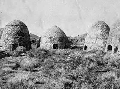
During the 1870s, miners staked many claims and organized mining districts. A couple of prospectors discovered a rich silver vein that became the fabulous Horn Silver Mine. Frisco, a wild boomtown nearby, sprang up in 1876. The Horn attracted famous investors, such as J. Pierpont Morgan.
The Frisco boom lasted only a decade. In the early 20th century, the Cactus Mine, near the town of Newhouse, west of Frisco, produced gold, silver, copper, and other minerals.
Transportation
Founded by livestock growers, Milford became an important transportation center when the Utah Southern Railroad reached the town in 1880. A month later the line was extended to Frisco. Trails carried ore and livestock to Salt Lake. Goods of all kinds came on the train to Milford, and from there, horse and wagon teams carried the freight to southern Utah, northern Arizona, and mining camps in Nevada.
Did You Know?
| The Tushar Mountains are the tallest mountains in Beaver County. These mountains were formed by the longest volcanic action in the state and now have the most concentrated and varied igneous rocks in Utah. |
| Clear Creek Canyon was a major transportation corridor and home to hundreds of the Great Basin’s first peoples. Now Fremont Indian State Park tells the story. |
| Wildhorse Canyon, 10 miles east of Milford, was a major quarry for obsidian in prehistoric times. People made weapons from this obsidian, and they carried it and traded it all over the West. |
| The first Mormon immigrants arrived in Beaver County in 1856. |
| Ira Hinckley established Cove Fort in 1860. Its rock walls provided protection, and it was also a stopping place between Beaver and Fillmore. |
In 1873 the U.S. Army established Fort Cameron at Beaver City to protect local citizens and to help bring the Mountain Meadows Massacre perpetrators to justice. |
Fast Facts
Area: 2,586 square miles
County Seat: Beaver
How it got its name: from the Beaver River, so-called because of the many beavers once found there
Main cities/towns: Beaver, Milford, Minersville
Economy: livestock, transportation, trade
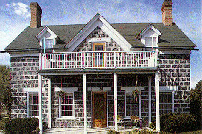
Points of interest: Beaver City historic homes, Frisco ghost town, Puffer Lake, Minersville Reservoir State Park, Mount Holly ski area
Return to the Counties home page here.
Return to the I Love Utah History home page here.