The wild and rugged Uinta Mountains rise up in the north part of Duchesne County—so the county can claim the state’s highest mountain, King’s Peak. During the Ice Age, many glaciers carved the Uintas. Today, the hundreds of lakes dotting the mountains are remnants of those glaciers.
Four major rivers have their source in the Uintas: the Bear, the Weber, the Provo, and the Green. Major streams running through the county include the Strawberry, Duchesne, Lake Fork, and Yellowstone rivers.
South of the mountains, the desert-like Uinta Basin gets a lot less rain and snow. The land is flat and rolling, broken by washes and gullies. The Tavaputs Plateau forms the southern rim of the basin, and the Wasatch Mountains form the western rim.
First Peoples
From 10,000 to 6,500 B.C., people in the Uinta Basin hunted big game such as mammoth and bison. During the next 6,000 years, called the Archaic period, people gathered plant foods in addition to hunting.
People called the Fremont came next. They lived in houses that were partly underground (called pithouses). They knew how to farm corn as well as to hunt and gather wild plants.
A band of Utes called the Uinta-ats lived in the Uinta Basin beginning in about A.D. 1300. Northern and Northwestern Shoshones sometimes visited the basin. At that time, the basin provided these people many resources for food, clothing, and shelter.
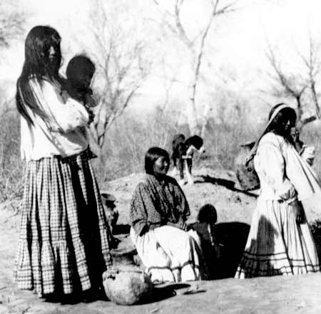
The Ute Indians
After white settlers came to Utah, their way of living and the Utes’ way of living just didn’t work together. Before too long, the settlers were demanding that the government get the Utes out of the way. So President Abraham Lincoln created a reservation in the Uinta Basin in 1861. Most northern Utes were forced to move from their traditional lands and go to the reservation.
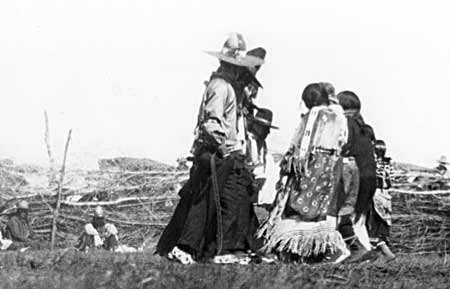
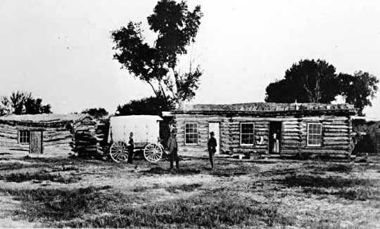
Women and Children at Whiterocks
In the 1880s the government created the Ouray Reservation south of the Uintah Reservation and moved Utes from Colorado to both reservations.
But the Utes did not even get to keep these arid regions. In the early 1900s, the U.S. government decided to make the Indians into farmers. They gave members of the three tribes individual parcels of land.
They then took parts of the reservation lands to create the Uinta National Forest and Strawberry Reservoir.
After that, they threw open the rest of the reservation to white homesteaders.
This left a much-reduced and disjointed Uintah-Ouray Reservation, which shrank from almost four million acres in 1882 to about 360,000 acres in 1909.
The Land Rush
Unlike much of the state, Brigham Young did not send settlers here. Instead, people came here of their own choice. And they settled the area much later than the rest of the state, beginning in 1905. That is the year the government opened the reservation to non-Indians.
Each family received 160 acres of land under the federal Homestead Act. In order to get the land, homesteaders had to prove that they intended to farm it. They had to live on the homestead for five years and make improvements to it. Or they could live on it for six months and pay $1.25 per acre. In either case, the government then gave the homesteader title to the land.
Many, many people came to get the free land. To profit from the land rush, A. M. Murdock, an Indian trader at Whiterocks, set up business at the site that became Duchesne City. With the help of others, he set up a large circus tent for a general store and post office. Other settlers soon arrived, pitched tents, and then built homes.
Not very much rain falls in Duchesne County, and the new farmers needed water. So Reuben S. Collett and William H. Smart, a church and civic leader, formed the Dry Gulch Irrigation Company in 1905. This company helped farmers to get water rights and build dams and irrigation canals. It is a flourishing company today.
The settlers formed other irrigation companies—some successful, and others not so successful. Homesteaders on Blue Bench, just north of the town of Duchesne, formed the Blue Bench Irrigation Company. The wealthy Jesse Knight of Provo helped finance the company. For many years, the homesteaders made heroic efforts to divert water from the Duchesne River to their farms on Blue Bench. But their efforts ended in failure for the farmers—and financial disaster for Knight.
In 1914, the Utah legislature created Duchesne County from part of Wasatch County. After a hard-fought battle between the towns of Roosevelt, Myton, and Duchesne for the county seat, Duchesne won the vote.
Economy
The county’s economy is based largely on the livestock industry. But in other areas, the county goes through boom-bust cycles.
The first happened when trappers came looking for fur-bearing animals in the 1820s to 1840s—then left. Next, came the discovery of Gilsonite, and then the rush for land in 1905. Later, oil and gas production has fluctuated up and down. Depending on the demand for oil and gas, sometimes many people work in the industry. And sometimes very few do.
Did You Know?
| Utah’s tallest mountain, King’s Peak, is 13,528 feet tall. |
| Much of the Utes’ reservation was taken and given to white homesteaders in 1905. |
| Teenagers in the Uinta Basin used a tea of sagebrush and quaking aspen bark to try to get rid of acne. |
| Duchesne’s Future Farmers of America chapter raised their own money to attend the Chicago World’s Fair in 1933. Many of the boys had never been outside the Uinta Basin. |
| An oil boom in the 1970s brought in lots of people. Another oil boom in recent years has likewise transformed the county. |
Fast Facts
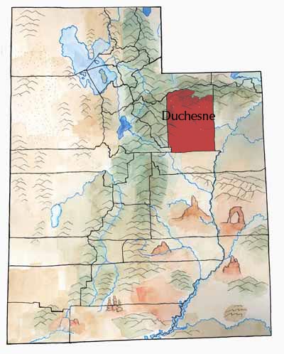
Area: 3,255 Square Miles
County Seat: Duchesne
Where it Got Its Name: Either after William H. Ashley, a Catholic nun in St. Louis, a French-Canadian Trapper, or after Ute word.
Main Cities and Towns: Roosevelt, Duchesne, Myton
Economy: Livestock, alfalfa, hay, oil, and natural gas
Keep Exploring!
Return to the County’s home page here.
Return to the I Love Utah History home page here.