Quick facts
Located in valleys east of the Wasatch Front, Morgan County is divided by the steep and rocky Weber Canyon, now the route of Interstate 84. Fifteen major streams empty into the Weber, so the county is well watered. In these high valleys and mountainous terrain, grasses, sagebrush, brush and small trees, and conifers grow.
First Peoples
This land, rich in timber, fish, deer, elk, birds, and more, offered many resources for humans. The Archaic culture and later Fremont culture probably lived on or traveled through the lands that later became Morgan County.
Around 1100 AD, Numic people began to enter Utah. When settlers entered Utah, Utes and Shoshone people passed through and camped in the valleys and along the rivers. They often camped in a meadow near the confluence of Peterson Creek and the Weber River. Settlers called the area “Wickiup” because of the wickiup shelters Native American people built in this area.
Explorers and Immigration
Fur trappers also traveled through the county. In 1825, near present-day Mountain Green, trappers of the British Hudson’s Bay Company under Peter Skene Ogden and competing American trappers got into a heated quarrel about who had the right to trap there. Several of Ogden’s men deserted him and joined the Americans.
Immigrants on their way to Salt Lake Valley came through the area, following East Creek to Mormon Flat.
Settlers
Thomas J. Thurston, who had originally come from Ohio, noticed the green valleys of Morgan when he and his two sons were cutting logs in the mountains east of Centerville in 1852. As they looked down from the mountains to the Weber Valley to the east, Thurston decided to explore further.
With two friends, he explored the valley and found plenty of fish and game. However, high mountains surrounded the valley. Getting to the valley meant traveling through the steep gorges of Weber Canyon. Even though some emigrant trains had traveled through the canyon, the route was still very rough.
But Thurston had a dream. In 1855 he finally talked some other men into improving the access to the canyon. With picks, crowbars, and small plows, they completed a rocky road into the valley.
The new settlers built homes at Weber City (later to be named Peterson) and further south at the future town site of Littleton. It wasn’t long before fifteen new settlements, including Morgan, had been formed in what is now Morgan County (which was created in 1862).
Railroad
When the Union Pacific Railroad laid track through the length of Weber Canyon in 1868-69, it literally put Morgan on the map. The railroad construction also helped establish a better, safer road that eventually became a major route and a “Gateway to the West.” Weber Canyon has also provided a corridor for communication lines, power lines, and oil lines.
Economy
Morgan has a larger percentage of privately owned land than any other county in Utah. The owners use much of this land for agriculture, especially beef and dairy cattle, sheep, poultry, mink farming, hay, wheat, and other field crops.
During 1860-75, lumber crews in Hardscrabble Canyon cut thousands of railroad ties to build the Union Pacific Railroad line. During the building of the UP Railroad in 1868, a number of businesses opened in Morgan City, and it became the county’s trade center. Some say it was the only incorporated city on the UP line between Ogden and Omaha, Nebraska.
Morgan County trees also provided charcoal that was used for smelting in the Salt Lake Valley and Bingham.
In 1904 the Morgan Canning Company opened as a pea cannery. The business grew, and the company built a second factory in Smithfield, Cache County.
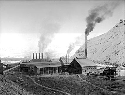
Morgan is home to Browning Arms and Holcim Inc. (a cement plant). The manufacturing of Portland cement is a major local industry. This important industrial product has been produced at the Devil’s Slide plant for more than 80 years.
In addition to limestone—the main ingredient in cement—silver, lead, copper, coal, iron, sulfur, and mica have been found in Morgan, but most mining has been on a small scale.
As it becomes more difficult for farmers to make a profit, much of the land is being sold for residential development.
Since Morgan’s industries don’t provide enough jobs for new residents, in recent years, more than half of those employed—the largest percentage in any county—have worked outside Morgan, mostly in the greater Ogden area.
Did You Know?
| The county had two Pony Express stations: Dixie Station and Bauchman Station. |
| When the Union Pacific was building the Transcontinental Railroad, it encountered its most difficult terrain in Weber Canyon. Here they could build only an average of two feet of track per day. |
| Weber Canyon is 1,000 miles from Omaha, where the Union Pacific began the railroad. |
| A company town on the Weber River named Devil’s Slide was named for a rock formation that looks like a huge slide. |
| The first “flying machine” in Morgan landed in 1923. People came from all over to see it. |
Fast Facts
Area: 603 Square Miles
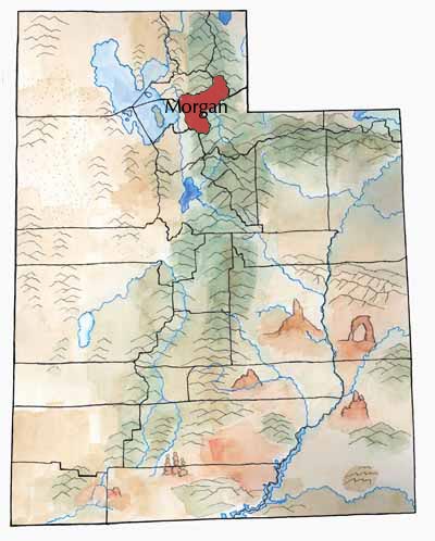
County Seat: Morgan
How it Got its Name: Jedediah Morgan Grant, a leader of the Church of Jesus Christ of Latter-day Saints
Main City: Morgan
Economy: Livestock, manufacturing
Keep Exploring!
Return to the County’s home page here.
Return to the I Love Utah History home page here.