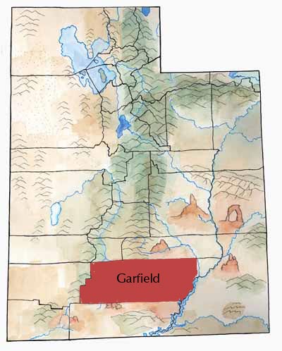
Garfield County is a land of colorful variety: high mountain plateaus, steep mesas, cliffs, slickrock, rock formations, gorges, natural bridges and arches, canyons, dry foothills and desert expanses. The county stretches from the eastern edge of the Great Basin to the Colorado River.
The Sevier River, gathering streams from the high plateaus, ends in a dead-end lake in the Great Basin.
The Escalante River gathers waters from dozens of creeks and washes and carries them to the Colorado River-Lake Powell.
The low desert can get hot, but much of the county lies at a high elevation. Panguitch, they say, has “nine months of winter and three months of [darn] cold weather.”* *Quoted in A History of Garfield County, by Linda King Newell and Vivian Linford Talbot, pp. 16 and 61.
First Peoples
The Garfield County area was home to both Ancestral Pueblo and Fremont cultures. And it seems that these two cultural groups interacted. For instance, at the Pueblo village at Anasazi State Park archaeologists have found pottery from both cultures.
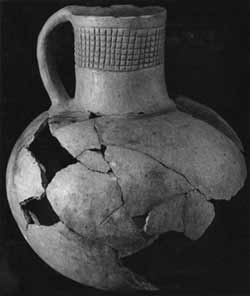
The ancient people left behind structures; traces of irrigation ditches and dams; pottery and baskets; tools such as axes, grinding stones, and arrow points; rock art; ornaments of shell, bone, and turquoise; traces of trails and roads; figurines, and more.
After the Ancestral Pueblo and Fremont cultures dispersed, Numic people moved in—people we call Southern Paiutes and Utes today. These people lived in small bands and hunted and gathered their food.
Settlers
The first white settlers made the difficult trip from Beaver and Parowan through the mountains to the Panguitch area in March 1864.
The winter was so hard that the town had a party in the spring. “We had pies made of bulberries and service berries and the Bishop made forty gallons of beer. We had plenty of chickens and other things to eat. . . . We had plenty of old time music.”*
The settlers didn’t stay long. After the Black Hawk War broke out the next year, they left.
Groups didn’t try settling in Panguitch again until 1871. Other settlers established other towns in the following years, including Escalante in 1876.
The territorial legislature created the county in 1882.
Settlers established the town of Boulder in 1889. For decades, the only road into town went over Boulder Mountain—and that road was closed in winter. So Boulder was the most isolated town in Utah.
In the 1930s the Civilian Conservation Corps (CCC) workers built a road from Escalante to Boulder. And what a job it was! They had to blast through rock and work on the sides of cliffs.
The CCC also reseeded ranges and built telephone lines, ranger stations, and trails.
Economy
Vast rangelands and some of the state’s largest forest reserves have made cattle ranching and lumber Garfield County’s most important industries since pioneer times.
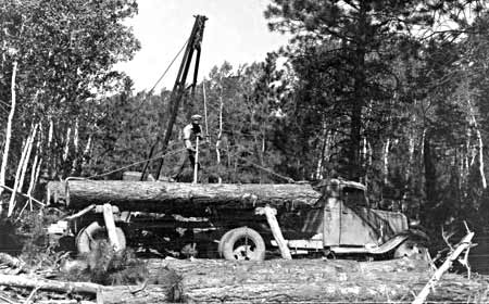
The forests also provide many recreational sites. People who love to fish love Panguitch Lake.
Bryce Canyon National Park, created in 1928, helped tourism grow. Other spectacular lands lie within the county, such as parts of Capitol Reef National Park and Glen Canyon National Recreation Area. Tourists looking for solitude, beauty, and outdoor recreation find plenty of these in Garfield County.
Unfortunately, the seasonal nature of lumbering and tourism often gives the county higher than average unemployment.
Garfield produces oil (at the Upper Valley oil field in central Garfield). It also has large coal fields as well as tar sands and uranium, but these energy-related resources have not been developed.
Did You Know?
| Ebenezer Bryce first settled the area around Bryce Canyon. He hated it when his cows got lost in that canyon! |
| During the terrible winter of 1864-65, residents of Panguitch nearly starved, until seven men traveled to Parowan to get flour. (They put quilts down so they could walk on the deep snow.) When they got back, the children “laughed and cried for joy to be privileged to eat real bread.” |
| A gold rush in the Henry Mountains drew prospectors in the 1890s. It was all over by 1911. |
| In 1914 the Hatch dam broke and a ten-foot wall of water swept away houses and destroyed crops and canals. |
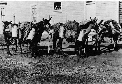
| Boulder was the last town in the U.S. to receive mail by mule—until around 1940. |
Fast Facts
Area: 5,158 Square Miles
County Seat: Panguitch
Where it Got its Name: Presidnet James A. Garfield, who had been assassinated
Main Towns: Panguitch, Escalante
Economy: Cattle, lumber, tourism
Keep Exploring!
Return to the County’s home page here.
Return to the I Love Utah History home page here.