Red sandstone, red soil, dark pine-covered mountains, lava flows, cliffs and canyons, cottonwood-lined streams and rivers, rolling dry country of mesquite and Joshua trees—these are some of the images of Washington County.
The eastern third of the county, including the spectacular Zion National Park, is part of the Colorado Plateau. The western two-thirds lies in the Basin and Range geographic province—but outside of the Great Basin.
The valley of the Virgin River and its tributaries have earned the nickname “Dixie” because it has the highest average temperatures in the state and very mild winters—making it possible to grow cotton there.
The lowest point in Utah, along Beaver Dam Wash (2,350 feet), is near the county’s southwest corner. The Pine Valley Mountains in the north rise over 10,000 feet.
First Peoples
Traces of the Archaic and Ancestral Pueblo cultures remain in this area: petroglyphs etched into rock, above-ground rock structures, and below-ground kivas and pithouses, along with other artifacts.
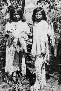
Later, Southern Paiute bands lived in the area, knowledgeably obtaining their sustenance from the land.
These people moved around harvesting plants and animals. They made their homes, clothing, baskets, containers, and other tools from plant materials. Sometimes they raised corn, squash, and beans, and ground their corn and seeds with a mano and metate.
The Dominguez-Escalante expedition in 1776 recorded the first description of the Native Americans in this area.
As elsewhere, white settlers pushed these people from their land. Some of their descendants now live on the Shivwits reservation near Ivins.
History
As early as 1852 Brigham Young sent small groups into southwestern Utah to test the agricultural potential of the warm climate. Settlers established Fort Harmony in 1852, Santa Clara in 1854, Washington in 1857, Toquerville in 1858, Grafton in 1859, and Adventure (Rockville) in 1860.
But until 1861, colonization remained mostly an experiment. In that year, LDS church leaders “called” several hundred families to go to the area to raise cotton, figs, olives, grapes, sugar, almonds, and tobacco. St. George, settled in 1861, was the principal settlement. The colonists succeeded in producing quite a bit of cotton, wine, and molasses. The demand for cotton lasted until after the Civil War.
During 1875-80 Silver Reef, northwest of Leeds, was a booming mining town, and Wells Fargo reportedly shipped more than $8,000,000 in silver bullion from the mines there. The wine industry grew during this period, but when mining slumped so did the demand for wine.
The boundaries of Washington County, formed in 1852 by the legislature, stretched the entire width of the territory (then some 600 miles). After several changes the county achieved its present size and shape in 1892.
Water
In dry country like this, the settlers had to give a lot of attention to obtaining water. The first settlements built dams on the Virgin and Santa Clara rivers. But floods kept washing the dams away.
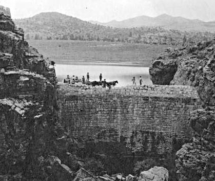
Later, the people of St. George decided to get water from springs on the Pine Valley Mountains—15 miles away. With teams, wagons, and scrapers, a canal took seven years to build, finally finished in 1898.
Up in the north of the county, Orson Huntsman had a vision to build a dam on Shoal Creek. After a lot of effort and sixteen years, the Enterprise Dam was finished.
The settlers of Hurricane also had a hard job to bring water to their fields. They dammed the Virgin River 7.5 miles above town, then built a canal into the sheer walls of the canyon: 8 feet wide and 4 feet deep. This one took 11 years, finished in 1904.
Even now water is a big issue, with all the people moving into the county, and all the golf courses that need watering. Quail Creek Reservoir was built in the 1980s—but a dike broke in 1989, causing millions of dollars of destruction. The dam was rebuilt.
Now people are exploring piping water from Lake Powell to take care of the county’s thirst.
Economy
The economic base of the county has changed a lot over the years. Most people lived by agriculture at the beginning. Now, the economy has a much more diversified mix.
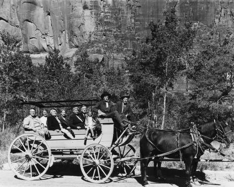
Zion National Park (established in 1909 as Mukuntuweap National Monument) has always been one of the state’s premier tourist attractions. Snow Canyon, golf courses, and other features also draw tourists.
The trade and service industries have grown steadily—not only for growing flocks of tourists but also to serve the many retirees and others who are moving to the area. Communities such as Bloomington and many condominiums and trailer parks house thousands of winter residents.
Utah Tech University (formerly Dixie State University) is also a major employer.
Did You Know?
| Early settlers in St. George had to get their family’s barrel of water out of the ditch at 5 a.m. before the cows were let loose to drink. |
| To get water to Hurricane, settlers built a 7.5-mile canal along a rock cliff. The canal brought water from the Virgin River to Hurricane for 80 years. |
| Silver Reef was a silver boom town by 1878, with 2,500 people, but the boom fizzled out by 1885. |
| The Zion Tunnel, built in 1930, made it easier for tourists to get to Bryce Canyon and the Grand Canyon. |
| On Hurricane Mesa, an Air Force contractor tested systems for safely ejecting jet pilots. |
Fast Facts
Area: 2,422 Square Miles
County Seat: St. George
Where it Got Its Name: From George A. Smith, a well-known member of the Church of Jesus Christ of Latter-day Saints
Main Cities and Towns: St. George, Washington, Hurricane, La Verkin, Santa Clara, Ivins, Springdale, Rockville, Hildale
Economy: Recreation, retirees, education, services, trade
Keep Exploring!
Return to the County’s home page here.
Return to the I Love Utah History home page here.